Nathan Rao
Guest Reporter
Brutally cold winds steered by a ‘plunging jet stream’ will scour the United States with crackling electric storms loaded with thundersnow.
The New Year is about to go bang as swathes of the country are put on alert for the worst winter blast in years.
A sub-zero plume loaded with freezing winds and heavy snow will take its strongest swipe across eastern states.
It will collide with warmer, tropical air across the south to detonate a spate of explosive winter storms.
AccuWeather chief on-air meteorologist Bernie Rayno said: “A strengthening storm is expected to bring snow, ice and possibly severe thunderstorms to parts of the central and eastern United States as it slides across the country this weekend into early next week.
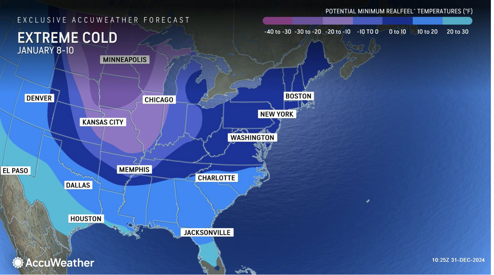
“Several Arctic blasts will bring waves of bitterly cold air to much of the eastern half of the nation, and in some places, this could result in the lowest January temperatures in more than a decade.
“We will be dealing with the coldest air of the season and multiple days of sub-zero temperatures.”
Battling warm and cold air will unleash torrents of ‘freezing rain’, turning roads and walkways into deadly ice-rinks.
They will also feed storms hurtling along the path of the jet stream turning them into eruptive tornado factories.
Mr Rayno said: “A storm barreling out of the Rockies will strengthen and create messy conditions that could impact millions of people this weekend.
“A battleground between competing warm and cold air this weekend may produce freezing rain, complicating travel.
LATEST DEVELOPMENTS:
“This zone can quickly turn roads icy, making travel dangerous, while excessive ice can bring down tree branches and power lines, leading to localized power outages.”
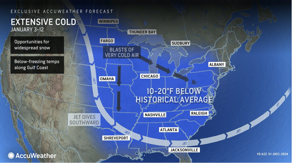
Dangerous weather through the start of 2025 will be driven by the jet stream as it swoops south towards the Gulf of Mexico.
Temperatures in parts of the region will nosedive to -30F, around 40F below average for the time of year.
Brutally cold weather is forecast to last through much of the month, with heavy snow driven by relentless storms.
A spokesman for the US National Weather Service (NOAA) said: “Colder air will sink
southward from central Canada into the northern Plains, eventually sweeping eastward.
“From the northern to eastern United States, temperatures will fall each day approaching average for New England, while below average temperatures stretch from northern Montana to the Mid-Atlantic and Southeast coasts.
“The colder air flowing across the still relative warmth of the Great Lakes will set up a favourable pattern for lake-effect snow showers.”
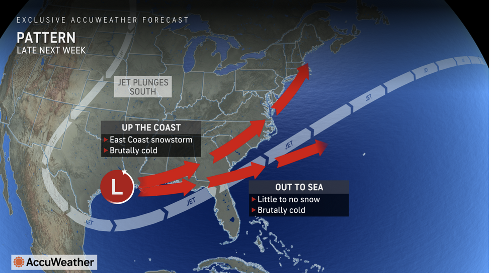
As cold air smashes into warmth to the south, violent storms will spin up into damaging tornadoes.
High pressure over the southwest will push temperatures into the 80Fs as thermometers bomb to the east.
Jim Dale, US meteorologist for British Weather Services and co-author of ‘Surviving Extreme Weather’, said: “While temperatures are still above average to the southwest, the cold air is never far away, and this week will see a huge drop in temperatures to the east of the country.
“Where the two air masses collide, there will be the risk of thunderstorms and tornadoes.”
Find Out More...
The New Year is about to go bang as swathes of the country are put on alert for the worst winter blast in years.
A sub-zero plume loaded with freezing winds and heavy snow will take its strongest swipe across eastern states.
It will collide with warmer, tropical air across the south to detonate a spate of explosive winter storms.

AccuWeather chief on-air meteorologist Bernie Rayno said: “A strengthening storm is expected to bring snow, ice and possibly severe thunderstorms to parts of the central and eastern United States as it slides across the country this weekend into early next week.
“Several Arctic blasts will bring waves of bitterly cold air to much of the eastern half of the nation, and in some places, this could result in the lowest January temperatures in more than a decade.
“We will be dealing with the coldest air of the season and multiple days of sub-zero temperatures.”
Battling warm and cold air will unleash torrents of ‘freezing rain’, turning roads and walkways into deadly ice-rinks.
They will also feed storms hurtling along the path of the jet stream turning them into eruptive tornado factories.
Mr Rayno said: “A storm barreling out of the Rockies will strengthen and create messy conditions that could impact millions of people this weekend.
“A battleground between competing warm and cold air this weekend may produce freezing rain, complicating travel.
LATEST DEVELOPMENTS:
- US weather: Polar blast threatens 'coldest January freeze for almost 15 years'
- US weather: Warm plume to bring 20C surge as ‘storm train’ set to return next week
- US weather: ‘Storm train’ set to give way to White Christmas

“This zone can quickly turn roads icy, making travel dangerous, while excessive ice can bring down tree branches and power lines, leading to localized power outages.”
Dangerous weather through the start of 2025 will be driven by the jet stream as it swoops south towards the Gulf of Mexico.
Temperatures in parts of the region will nosedive to -30F, around 40F below average for the time of year.
Brutally cold weather is forecast to last through much of the month, with heavy snow driven by relentless storms.
A spokesman for the US National Weather Service (NOAA) said: “Colder air will sink
southward from central Canada into the northern Plains, eventually sweeping eastward.

“From the northern to eastern United States, temperatures will fall each day approaching average for New England, while below average temperatures stretch from northern Montana to the Mid-Atlantic and Southeast coasts.
“The colder air flowing across the still relative warmth of the Great Lakes will set up a favourable pattern for lake-effect snow showers.”
As cold air smashes into warmth to the south, violent storms will spin up into damaging tornadoes.
High pressure over the southwest will push temperatures into the 80Fs as thermometers bomb to the east.
Jim Dale, US meteorologist for British Weather Services and co-author of ‘Surviving Extreme Weather’, said: “While temperatures are still above average to the southwest, the cold air is never far away, and this week will see a huge drop in temperatures to the east of the country.
“Where the two air masses collide, there will be the risk of thunderstorms and tornadoes.”
Find Out More...
